
O. Fajuyigbe
Department of Computer Science, Federal University of Technology, Akure, Ondo State, Nigeria
V.F. Balogun
Department of Computer Science, Federal University of Technology, Akure, Ondo State, Nigeria
O.M. Obembe
Department of Computer Science, Federal University of Technology, Akure, Ondo State, Nigeria
Information Technology Journal
Year: 2007 | Volume: 6 | Issue: 5 | Page No.: 613-622


ABSTRACT
The Tourism industry in Nigeria is a growing one and already governments are underway to support the effective management and promotion of the industry. Several attempts to enhance this development have suffered some drawbacks due to inadequate access to information of tourism facilities, destinations and services. This paper emanates from a project that was carried out at the Department of Computer Science, Federal University of Technology, Akure, Nigeria. It discuses how a Web-based Geographical Information System (GIS) is used for the rendering and analysis of tourism information for the efficient management and promotion of tourism. A typical model of a Web-Enabled GIS for tourism was implemented using the Oyo State, (Nigeria) tourism as a case study.
PDF Abstract XML References Citation
How to cite this article
O. Fajuyigbe, V.F. Balogun and O.M. Obembe, 2007. Web-Based Geographical Information System (GIS) for Tourism in Oyo State, Nigeria. Information Technology Journal, 6: 613-622.
DOI: 10.3923/itj.2007.613.622
URL: https://scialert.net/abstract/?doi=itj.2007.613.622
DOI: 10.3923/itj.2007.613.622
URL: https://scialert.net/abstract/?doi=itj.2007.613.622
INTRODUCTION
Tourism is defined by the World Tourism Organization (NSCB, 2004), as the act of traveling for the purpose of recreation and the provision of services for this act. It further explained that a tourist is someone who travels at least eighty kilometers (fifty miles) from home for the purpose of recreation. To a lay-man, tourism could just be the act of visiting other places for the purpose of sight seeing and enjoyment but the activities of tourism are more than that. In another term, Tourism is said to be the activities of people traveling to and staying in places outside their usual environment for not more than one consecutive year for leisure, business and other purposes related to the exercise of an activity remunerated from within the place visited. As a service based industry, tourism consists of a number of tangible and intangible elements or components. The tangible elements include basic infrastructures such as transport, accommodation, tours, souvenirs, while the intangible elements includes education, culture, adventure or simply escape and relaxation.
The tourism industry in Nigeria is a developing one and Oyo state is fast becoming a leading destination for tourists into the country. With this new development, government is making efforts through the board of tourisms to develop and maintain this sector as a major source of revenue for the state and country. With the global expansion in urbanization and the increasing stress of urban life, people search for places to relax, ease their stress and leisure and the natural sites in Oyo State are obvious choices.
THE STUDY AREA: OYO STATE TOURISM
Oyo state, which has as its capital Ibadan, the second largest indigenous city in black Africa, is blessed with a lot of breathtaking attractions centers that can catch the fancy of tourist. Oyo State is located in the south West Region of Nigeria. Latitude 7 degree North and longitude 4 degree East bisect the state into four nearly equal parts. The State covers a total of 27,249 sq. km of landmass and is made up of 33 local governments. The topography of the state is one of gentle rolling lowland in the south, rising to a plateau 40 m and above in the north. The state is well drained with rivers flowing from the upland in the North/South direction. The major rivers are Ofiki, Ogun, Shasha, Oba, Opeki and Ogunpa flowing through Ibadan (OYCTB, 2005).
The climate in Oyo state is equatorial notably with dry and wet seasons with relatively high humidity. The state landscape consist of old hard rocks and dome shaped hills which raise gently from about 500 m in the southern part and reaching a height of about 1,219 m above sea level in the northern parts. The vegetation is mostly evergreen forest where lumbering plantation farming of oil palm, cocoa etc. is encouraged. The presence of tourist places with natural features in addition to traditional, cultural and geographical monument makes Oyo state irresistible to tourists. Examples of such attractions are the Ado-Awaye hills and suspended lakes, Iyanla hills, Asabiri hills, Iyamapo hill, old Oyo national park, Captain Bower’s tower and Ikere gorge dam among others. Other interesting places are the mysterious Ajagbon tree in Ogbomoso town, which is reputed to be older than the town itself, Sogidi River a sacred river situated in Aawe, Agodi gardens, Trans amusement park and the zoological garden amongst others. The last three tourist centers mentioned above, namely the Agodi gardens, Trans amusement park and zoological garden all situated in Ibadan serve as recreational centers, play grounds and other sporting activities. Oyo state is also endowed with traditional industries that engage in black soap making, calabash carving at Akinyele local government area and cloth weaving at Iseyin and Ogbomoso towns. The materials used in these industries are based on local raw materials. These products can serve as gifts items for tourists. The state is also rich in annual cultural festivals like Oke- Ibadan, Orisa Oko, Oro, Egungun, Ebo-Oba, Ebo Orun, Gelede, to mention a few. The state also has a number of important shrines streams, carves and royal homes like the Aafin in Oyo towns. In the area of hospitality industry, Oyo state has a number of good hotels K.S, D castle Inn, Lafia hotels, Premier hotel amongst others.
PROBLEMS OF TOURISM IN OYO STATE
Due to the discovery of tourism potentials in Oyo State, several attempts have been made to enhance its development. However, these attempts have suffered some drawbacks which include:
| • | Difficulties in updating existing graphical tourist guides and maps (expensive, tedious and time consuming) |
| • | Lack of digital information for tourism facilities and destinations. |
| • | Lack of comprehensive information based on the internet |
| • | Inadequate motivation for effective marketing |
| • | Inadequate analysis of the state’s tourism |
| • | Inadequate and insufficient promotion of the state tourism. |
| • | Lack of a technology-driven approach for the state’s tourism. |
The reasons for the drawbacks above form majorly the motivations for this project i.e. to design a database containing information of tourism facilities in Oyo State and to develop a web enabled GIS for tourism in the state.
METHOD OF SOLUTION: THE GEOGRAPHICAL INFORMATION SYSTEM
Geographical Information System (GIS) can be regarded as the high technology equivalent of map in the field of geography. An individual map contains a lot of information which is used in different ways by different individuals and organizations. Maps represent the means of locating oneself in relation to the world reference point. Maps are used in diverse application, from locating telephone wires and water distribution pipelines to displaying the extent of deforestation in a region. The map has been in existence in much the same form for thousands of years. In the traditional form, a map suffers from a number of problems. Firstly, maps are static and therefore difficult and expensive to keep to date. Secondly, maps exist as discrete sheets and therefore the area of interest of a map use lies on the corner of the four adjacent sheets. Thirdly, maps are often very complex and may require an expert to extract a particular data which are of interest (Douglas, 2000). GIS however provides the facility to extract the different sets of information from a map and use them as required. Roads, settlements, vegetation, land use data and so forth can be extracted from a GIS. Thus, GIS provides flexibility, allowing a paper map to be quickly produced which exactly meets the needs of the user. GIS even goes further (since the data are stored on a computer) to make data analysis, modeling, simulation and mining become possible. For example, one might point to two buildings and ask the computer to find the distance between the two buildings.
COMPONENTS OF GEOGRAPHICAL INFORMATION SYSTEM
According to ESRI (1995) there are four basic components of GIS namely:
Hardware: Hardware comprises of the equipment needed to support the many activities of GIS ranging form data collection to data analysis. The central piece of equipment is the workstation, which runs the GIS software and is the attachment point for ancillary equipment. Data collection could be done using the GPS (Global positioning System) device. Other hardware equipments include scanners, digital and video cameras, printers, plotters etc.
Software: Different software packages are important in GIS. Central to this is the GIS application package. Such software is essential for creating, editing and analyzing spatial and attributes data; therefore these packages contain a myriad of GIS functions inherent in them. Examples of software include, Arc View, Arc Info, Idrisi, Map Objects, Map Viewer, ErMapper etc.
Data: Data is the core of any GIS. There are two primary types of data that are used in GIS. A geo-database (spatial data) is the database that is in some way referenced to locations on the earth. Geo databases are grouped into two, Vector and raster, coupled with this data is usually data known as attribute data. Attribute data generally defines as additional information, which can be tied to spatial data.
People: Well-trained people knowledgeable in spatial analysis and skilled in using GIS software are essential to the GIS process. There are three factor to the people component namely; Education, career path and networking.
GIS AND WEB TECHNOLOGIES
GIS has been widely used in solving a variety of planning problems. Together with the use of the Word Wide Web, GIS could be further developed to allow many more people to have access to GIS functionality and to enhance community participation in planning. Public participation is an approach in which the public is brought to play an active role in the planning of the GIS (ESRI, 1995). The rapid growth of the Internet provided highly customized, accessible and interactive source of public information and is changing the ways that people capture and manipulate spatial information. It is expected that the implementation of Web-based GIS could provide interactive mapping and spatial analysis capabilities for enhancing public participation and collaboration in decision-making processes. A public participation approach situates GIS analytical tools within an expanded framework of communication and discourse, opening opportunities for public participation (Foote and Kirran, 1997). Public Participation GIS (PPGIS) is conceived broadly as an integrative and inclusive process-based set of methods and technologies amenable to public participation, multiple viewpoints and diverse forms of information (Krygier, 1997).
HOW WEB-BASED GIS WORK
There are many different products that can be used to implement Web-based GIS as described in this section. They include Map Guide, Map Objects, ProServer, GeoMedia Web Map, Spatial WebBroker, APPIAN Carta, Spatial Net and CARIS Internet Server. The entire process of communication between server and client to produce a map is illustrated below. Once a user is on a map-enabled Web site, the following steps are required to request and receive a new map:
| • | User makes request for map (for instance, user selects zoom option, then clicks on the map) |
| • | Request is sent to the Web Server in the form of a URL |
| • | Web Server hands request off to ESRIMap.dll |
| • | ESRIMap.dll makes request to the location on the server network where the MapObjects application is running |
| • | MapObjects creates the new map from the GIS Database |
| • | New map is saved as a. jpeg file in a location outside the Web Server’s firewall |
| • | Web Browser retrieves the. jpeg file from the saved location and displays on screen (Favazza, 1998) |
ELATED WORKS AND THEIR LIMITATIONS
Research and development activities in the use of GIS in various aspect of life are a little more than 6 decades old, with the first system (the Canadian GIS) implemented in 1960. In the early 1990’s, the United States Department of Justice, recognizing the value of geospatial data and techniques in managing crime, established partnerships with local law enforcement organizations to illustrate the value of GIS applications in the identification, visualization and analysis of crime trends locally and regionally. Hence, the Regional Crime Analysis GIS (RCAGIS) was developed to provide police officers, crime analysts, investigators, chiefs, commissioners, sheriffs and manages a powerful, yet easy to use crime mapping analysis and reporting application (SDI Cookbook, 2000). The Ghana Geographical Information System developed by Longmatey et al. (2002) was designed to use GIS as a common platform to provide a spatial data bank with integrated multimedia features. It presents GIS in tourism management and promotion in Ghana on the desktop which when implemented provides critical data and information required to serve the tourism market. A good look into the sited works developed with GIS above, a number of limitations are identified, though they are basically technological limitations:
| • | For those developed before the era of pronounced network facilities, they were basically used on a standalone system. |
| • | Those developed on network facilities e.g., RCAGIS were not internet based. |
| • | Many don’t have the facility for public participation on their GIS. |
In view of these limitations, the research work seeks to present an Internet based Geographical Information System that allows for public participation for tourism in Oyo state.
ANALYSIS OF THE EXISTING SYSTEM
Tourism in Oyo state is being managed by the Oyo state culture and tourism board situated at Ibadan, the state capital. At the inception of the board, the board was to revitalize and upgrade the standard of the state’s tourism with the aim to properly maintain the growth of the industry in the state. In their aim to achieve the board’s objective, managers were kept at each tourist centers, protections were kept at each tourist centers around the state, tourist services like food were kept in place, tickets are available for income from tourism to the state and other tourist facilities like accommodation, transport and others were kept in place. Thus, if a group of tourist were to visit the state, they get in contact with the state tourism board. The board then fixes a tour date while all managers at intended tourist sites are notified of the tour. In other cases where individuals are to reach tourist centers around them, they need not get through the board if they know their route, the managers at the tourist centers will take them through the place.
METHODS OF DATA ACQUISITION
Data collection for the project was done using both the primary and the secondary acquisition methods.
Primary data: These are data collected through interviews and observation. The interviews conducted (basically oral) include unstructured interviews with members of the state tourism board, managers of state tourist centers, Ministry of Information, Oyo state and the department of survey, Oyo State Ministry of Lands and Housing. The GIS expert at the Federal School of Survey, Oyo town (who happens to be our collaborator and the source of the licensed Arc View used for this project) was also interviewed. The various tourist sites were also explored and giving closer observation.
Secondary data: These include data collected through tourism journals, books, existing and relevant literatures on tourism, GIS and computer graphics. Others include information from the Internet and the Tourism Library of Oyo State, Nigeria.
SYSTEM ARCHITECTURE
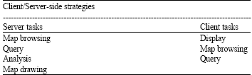
There are basically two types of architectures for developing Internet-based GIS applications: client-side and server-side.
| Table 1: | Client/Server or Hybrid side Strategies |
 | |
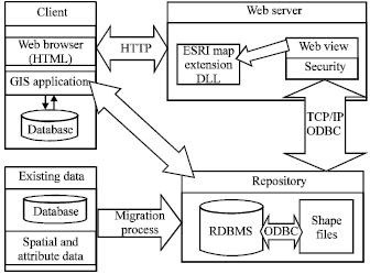 | |
| Fig. 1: | Architecture of the Web Enabled GIS |
| • | Server-side architecture allows users (clients) to submit requests for data and analysis to a Web server. The server processes the requests and returns data or a solution to the remote client. |
| • | Client-side architectures allow the users to perform some data manipulation and analysis locally on their own machines. |
The system was designed by using a combination of both the server-side and client-side architectures in what can be called a Hybrid or Client/Server architecture as proposed by Ban and Chang (1999). The design allows the user to use both (server and client) design techniques to access the GIS on the internet (Table 1). In this Design architecture, the user can make a request to the web server through the Web browser and the Web server generates the http request in form of an html page like the server-side design or access GIS data (shapefiles, Data etc.) from the Internet through its GIS package which will enable for manipulation on client system. The architecture of the Web-based GIS for Oyo State is shown below (Fig. 1).
THE GIS DATA DESIGN
The GIS data includes both the spatial data and attribute data, the spatial data being a database that is in some way referenced to locations on the earth and attribute data which consist of additional information to the spatial data e.g., images, texts etc. The core of the database, the spatial component, was developed using ESRI’s Arc VIEW software which was used with the permission of the Federal School of Survey, Oyo, Nigeria (the owner of the licensed Arc View). It was also used as a front end development platform for enhanced cartographic presentation and visualization.
GEODATABASE (SPATIAL DATA) CREATION
In order to provide enhanced cartographic representation, the digital maps were developed using Arc view GIS software. Labels and suitable graphic symbols were assigned to the various features for easy categorizations, identification and visualization. Tourism facilities like roads, hotels, transport were classified. Thus, concise digital tourist maps (shape files) were created. The procedure followed in the development of the map shape files included the following;
| • | Acquisition of graphical maps covering the entire Oyo state and Ibadan being the state’s capital. |
| • | A quick tour of all tourist centers to verify the existence of tourism features and relative positions from each other (determining the reliability). |
| • | Converting the proper maps to digital maps by digitizing it using Arc View GIS 3.2a |
| • | Editing to remove errors |
| • | Creation of the database for each themes (shape file) |
| • | Creation of relationships, queries and reports between map features. |
ATTRIBUTE DATA CREATION
Attribute information on the various tourism facilities that were collected from different sources were linked to their respective spatial features. This includes the following process;
| • | Compilation and addition of text information to features and locations in tables. |
| • | Creation and editing of images to text labels |
| • | Attaching images to spatial feature using the hotlink feature |
A hotlink to a feature on the map could display an image, a text file, an existing project or program as shown in Fig. 2.
 | |
| Fig. 2: | Attribute data (images, text) |
DATABASE SPECIFICATIONS
The map shape files database was designed using Arc View’s back-end (database) facilities, the database specification for the GIS shape files are shown explicitly below:
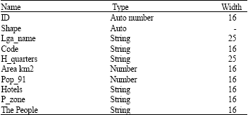
Oyomap.dbf: This database Table 2 contains the details of the oyomap.shp shape file which shows the total block diagram of the map of Oyo state. It shows Oyo state as a whole with its general information.
lga.dbf: Table 3 contains the information about the 33 local government areas of Oyo state, their properties, tourism information, location, facilities etc. the structure is shown in Table 3.
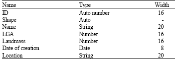
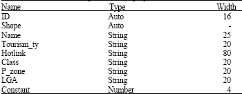
Touristspots.dbf: This database contains information about the tourist attractions sites in the state. It is the backbone of the touristspot.shp which displays tourist spots by location and displayed text labels, images when displayed, the hotlink field in the helps for the image linking. Its structure shown in Table 4.
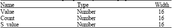
Proximity to touristspot.dbf: This file makes analysis the distance in proximity within the each tourist centers using the Table 5.
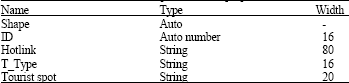
Ibtouristspots.dbf: The hotlink on shape file iblink will load up the ibgisproject.apr where the GIS of Ibadan lies. The ibtouristspot.dbf contains general information about the tourist places for Ibadan (Table 6).
| Table 2: | Details of Oyomap database properties |
 | |
| Table 3: | Details of Lga database properties |
 | |
| Table 4: | Details of tourist spots database properties |
 | |
| Table 5: | Details of tourist spots proximity database properties |
 | |
| Table 6: | Details of Ibadan tourist spots database properties |
 | |
MAP SERVING TECHNIQUE
The spatial and attribute data creation were done using Arc View 3.2. The maps (themes) created through this product were served to the Internet using Web View Standard Edition. This product is an Add-In component of Arc View. Upon the installation of the software, it is added to the Arc View’s extension list and used to serve the maps (themes). Web View works almost like a web creation wizard, it uses shape files and database already created and settings to create all possible web maps needed to answer all queries that may be asked by the user of the system. Having designed the themes, the procedure of serving maps using Web View includes:
| • | Select (Activate) themes that are needed to be served in Arc View. |
| • | Click on the Web View icon on the toolbar |
| • | On Web View step 1: Select preferred view properties. |
| • | On Web View step 2: Select preferred Layer Properties e.g., interactive, attributes, hotlinks etc. |
| • | On its Step 3: Select appropriate web properties. |
| • | Finalize the process and wait while Web View creates appropriate HTML pages in a specified folder. |
The HTML pages of the served map are created and generated automatically by Web View, thus an appropriate link was used from the Website design to activate the served maps on the internet.
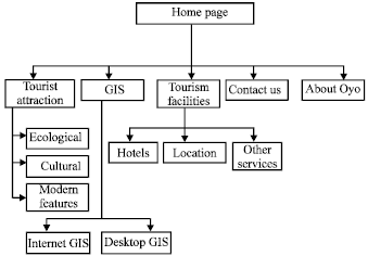
WEBSITE HIERARCHICAL DESIGN
The hierarchical system design is concerned with the internal processing functions. The splitting of high level functions into sub functions and establishing definite relationships and interconnection among specified functions.
 | |
| Fig. 3: | Hierarchical design of the web enabled GIS system |
The diagram is shown in Fig. 3.
GIS OUTPUT DESIGN
The GIS output realized in this project are of two types namely the internet GIS output and the desktop GIS output. This is as a result of the dual design used in the architectural design of the system.
DESKTOP GIS OUTPUT
The customized query model for the project was developed for a query in text, report and graphic format. The following are the major queries exercised during the development of the spatial database of Oyo state.
| • | The overall view of the terrain characteristics of the state. |
| • | The locations of the tourist spots in relation to the topography (Fig. 4). |
| • | The detail information about each spots on the land terrain. |
| • | Tourism facilities and services. |
| • | Distances between tourist spots, local government areas on the topography. |
| • | Road networks between tourist centers and within the terrain (Fig. 5). |
| • | State boundaries around the topography. |
| • | Images, text and other information about the tourist spots using hotlinks. |
| • | Population density of the state, which could help to forecast tourist visitation populace. |
| • | Project link to the state’s capital (Ibadan) GIS. |
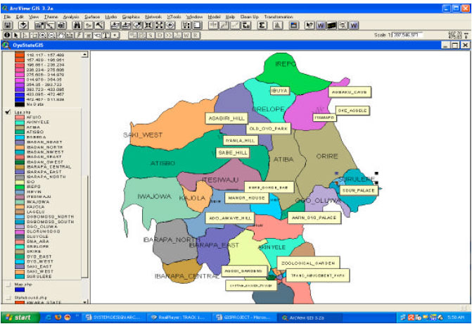 | |
| Fig. 4: | Tourist location within Oyo topography |
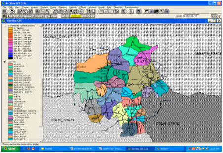 | |
| Fig. 5: | Oyo state road network including boundary states. |
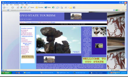 | |
| Fig. 6: | Homepage of the Web-enabled GIS for oyostatetourism |
THE WEBSITE
Once the website as been uploaded over the internet, the user enters the address of the site and the site gets running, the homepage is the first page to be seen by the user. It contains a heading and other links to the other pages on the website. The home page is shown in Fig. 6.
The different types of tourist centers are shown according to classification. This page houses the link to all the tourist centers and information on the website. A click on the Ecological button takes the website to the full ecological pages as shown in Fig. 7.
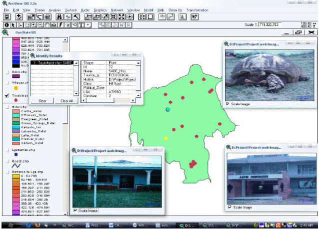
The GIS Link on top of the webpage’s is the link to the spatial information of the tourist centers. This allows for tourist to determine the locations of the tourist centre on the digitized base map of Oyo State. The GIS page is as shown in Fig. 8.
This page consists of a detail map and an Overview map. The Overview Map displays the overview themes and displays the whole area. A red rectangle shows where the area displayed in the detail map is located (Fig. 8). The features on this page include
| • | Searching for location of tourist centers |
| • | Identification of tourist spots i.e. Name and Information. |
| • | Overlapping of other themes e.g. roads to note movable areas towards a particular tourist centre. |
| • | Display location of other features like the hotels |
| • | Image display of Tourist centers. |
The hotel link of the pages leads to the hotel page. Here, the names and address of some of the hotels available for tourists into the state are displayed (Fig. 9).
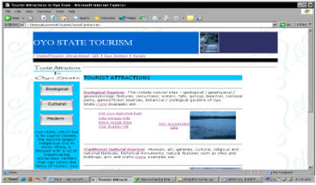 | |
| Fig. 7: | Tourist attractions page |
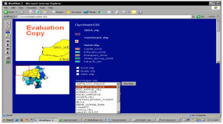 | |
| Fig. 8: | Tourist centers GIS page |
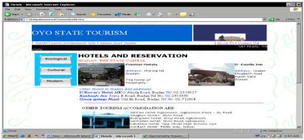 | |
| Fig. 9: | Hotel and reservations page |
SYSTEM INSTALLATION
The new system’s configuration will be discussed in two perspectives. Firstly, the administrator side which in this system model is believed to be the Oyo state Tourism board. This system is designed to be maintained by the board so a Geo-Informatics department is expected to be in-place by the board to monitor the system well enough. With a minimum of the hardware and software requirements above in place, The boards system setup would be like:
| • | Install a Geo-coding Engine like Arc View if not installed before. |
| • | Add all the designed themes on the installation CD into the GIS package. |
| • | Analyze and manipulate related and necessary data |
| • | Install a web server, Microsoft IIS or Apache. This is to allow for connection to the internet. |
| • | Acquire new data from time to time to refresh the data over the internet. |
And secondly, the tourist using the web service, his or her system setup would be like:
| • | Installing a web browser, Internet Explorer, Netscape or other to browse the website and get information. |
| • | Install a GIS package like Arc view, Arc explorer or a Map viewer if personal spatial analysis would be a choice. |
CONCLUSIONS
This project puts Geographical Information System in tourism management and promotion in Oyo state on the Desktop as well as the World Wide Web (Internet), which when fully maximized will provide critical data and information required to serve the tourism market. The result of this research project have revealed that presenting tourism information in GIS in a computer environment and the internet would offer an unparallel platform for the management and promotion of the tourism industry in Oyo State. Tourism agencies, tourists and the people at large would have access to comprehensive information and thus serve as a great source of motivation to boost the performance of the tourism sector. Adequate incentive can thus be assured for efficient marketing and promotion. Moreover, difficulties in updating existing graphical tourist guides and maps could be eliminated.
This process would now become less expensive, easier and less time consuming.
FUTURE RESEARCH DIRECTION
The use of this application on the internet is relatively easy for anyone to use effectively. The potential use of this type of technology is virtually limitless. From dispersion of tourism information to exchange of technical data, this technology can add an intuitive spatial element to many different types of information. Though the best of the internet GIS methods was not implemented in this project, it is needless to say that this project could be taking to the next level of enhanced and better GIS using better Map server technologies and GIS packages that can enable seamless and efficient distributing and deployment of maps via the internet. It is believed that new versions of Environmental Systems Research Institute GIS package or other relatively high Software could do well to improve the quality of this project work. In a later work, we shall integrate the GIS and the Virtual Reality (VR) technologies so as to enable prospective tourists have a real time walkthrough of some of the tourist centers via the Internet.