
Xiongwen Chen
Center for Forestry and Ecology, P.O. Box 1927, Alabama A and M University, Normal, AL 35762, USA
Journal of Applied Sciences
Year: 2006 | Volume: 6 | Issue: 1 | Page No.: 144-150


ABSTRACT
This study analyzed the recent (1950s-1990s) precipitation variation at three typical locations (Yangjiang, Tuoli and Changling) in three climate regions (humid, sub arid and arid) or biomes of China. Precipitation variations at these locations have both similar and different characters. The fluctuation in annual precipitation is highest at Yangjiang. The probabilities of anomalous precipitation at three locations are more than 50%. Multiple time cycles of annual precipitation exist at three locations. The average coefficient of fluctuation at Changling and Tuoli after 1980 is significantly higher than it before 1980, but for Yangling it is slightly lower than that before 1980. The evenness of precipitation in the growing seasons at both Tuoli and Yangjiang is higher than that at Changling. Multiple time cycles also exist in the evenness of precipitation in the growing seasons at three locations and they changed after 1975. The occurrences of extreme annual precipitations at three locations have strong agreement with El Niño-Southern Oscillation (ENSO) events. Higher precipitation has a higher probability of coinciding with ENSO warm phase; lower precipitation has a higher coincidence with ENSO cold phase. The interaction between ENSO and monsoons may partly explain the precipitation variation at three locations in this study.
PDF Abstract XML References Citation
How to cite this article
Xiongwen Chen, 2006. Comparison of the Recent Precipitation Variation at Three Locations in China. Journal of Applied Sciences, 6: 144-150.
DOI: 10.3923/jas.2006.144.150
URL: https://scialert.net/abstract/?doi=jas.2006.144.150
DOI: 10.3923/jas.2006.144.150
URL: https://scialert.net/abstract/?doi=jas.2006.144.150
INTRODUCTION
The global warming of recent decades is continuing and the calendar year 2001 was the second warmest year on record in more than a century of instrumental data[1]. Ecological processes are influenced by prevailing climatic conditions[2, 3]. The average first flowering date of 385 British plant species has advanced by 4.5 days during the past decade compared with the previous four decades[4]. Climate fluctuation is identified as one of the key factors for invasion by non-resident species[5]. These ecological effects operate through local weather parameters such as temperature, wind, rain and snow, as well as interactions among these. Climate variations drive temporally and spatially averaged exchanges of heat, momentum and water vapor that ultimately determine plant growth, recruitment and migration patterns[3]. Although surface air temperature is believed to have increased about 0.5°C over the past 25 years[6], precipitation changes at different locations are complicated, including the increased variation in precipitation regimes[7]. Because water supply is crucial to all terrestrial ecosystems, precipitation is a fundamental concern of the impact of the climate change[8].
Most biomes and ecosystems are at risk of being affected by projected increases in rainfall variability. Knapp et al.[9] made an assessment for responses of a native grassland ecosystem to increased variability in rainfal. Their results indicated that projected increases in rainfall variability can rapidly alter key carbon cycling processes and plant community composition, independent of changes in total precipitation. Hanson and Wullschleger[10] made a comprehensive assessment about North American temperate deciduous forest responses to changing precipitation regimes. Exotic grass invasions into California serpentine grasslands increased following wet years[11]. It is necessary to study the recent precipitation variation at different locations or spatial scales and analyze the possible causes, because: (1) it is valuable to identify characteristics of exceptional climatic conditions (such as droughts and floods); (2) it offers a potential for us to understand climate change, variability and their causes; (3) it is useful for simulating past, present and future climate; and (4) we can characterize climatic variations and assess the potential consequences of climate change so that we can carry out proper policy to mitigate climate disasters.
China is a large country with a varied and uneven distribution of climatic regions[12]. During the last 40 years the air temperature has increased about 0.24°C every decade in the area of north of 35°N in China and it will likely continue to increase[13]. Climatic change will greatly affect China’s original climate condition and the corresponding ecosystems[14]. In order to properly understand the potential impacts of climate change on China’s ecosystems, it is important to analyze the precipitation variation from recent decades in different climate regions. In this study we analyzed precipitation patterns at three locations, which are in China’s different climatic regions (humid, sub arid and arid regions). The aims of this research was to find out some characteristics of the annual precipitation variation and precipitation in growing seasons, because the precipitation change in growing season would directly impact the plant growth and to analyze possible causes and their relationship with El Niño- Southern Oscillation (ENSO).
MATERIALS AND METHODS
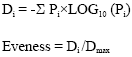
Study sites: In order to study recent precipitation variation at different climate regions or biomes, three locations (Yangjiang, Tuoli and Changling) in humid, sub arid and arid climate regions with typical climate condition in tropical rainforest, temperate desert and temperate meadow were chosen (Table 1). The climate variation at these three locations may represent the climate at the corresponding regions because there are typical climate conditions at these locations. The geographical and bio-climate condition and data length of precipitation at these locations are listed in Table 1.
The aim of this study was to analyze the precipitation variation at the short time period, which may be related to ecosystems functions at recent time. Based on the limited observation data, three indices (the coefficient of fluctuation, evenness of precipitation in the growing season and time cycles of annual precipitations) were chosen. The details were listed as the followings.
The coefficient of fluctuation (CF) is estimated as the following:
where, pi is annual precipitation, P is average of long term annual precipitation.
The growing season is referred to the time period from April to October.
Evenness of precipitation in the growing season is calculated as the following[15]:
 |
Where, Pi is the proportion of monthly precipitation (April-October) in the total precipitation of the growing season in the corresponding year.
One way ANOVA was used to compare the differences between the evenness of precipitation in the growing season at three locations.
| Table 1: | The background information of three locations |
 | |
| * Wu[29] , ** Chang[30] | |
Spectral analysis was used to estimate time cycle period of annual precipitations by STATISTICA (StatSoft, USA).
RESULTS AND DISCUSSION
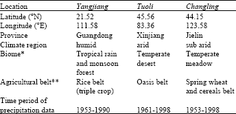
Characteristics of long term precipitation at three locations: Yangjiang has the highest mean long term annual precipitation with about 2290 mm (Fig. 1); Tuoli has the lowest long term annual precipitation with a mean of about 236 mm. The mean annual precipitation at Changling is about 467 mm. Yangjiang also has the highest annual precipitation fluctuation of up to 1800 mm. However, maximal between-year fluctuations in annual precipitation at Tuoli and Changling are only about 180 and 470 mm, respectively. Although the regression is not statistically significant, there is a general trend of increasing precipitation at Yangjiang and there is general trend of decreasing precipitation at Tuoli and Changling. There is a precipitation cycle of peaks or troughs every 2-3 years at Yangjiang. Peak precipitation years are usually followed precipitation troughs the following year. The annual precipitation changes dramatically. However, at Tuoli the precipitation cycle period is about 3-4 years and the annual precipitation change has low amplitude. At Changling the precipitation cycle period of peaks and troughs is about 3-4 years and its annual change amplitude is intermediate type between Yangjiang and Tuoli. The precipitation at Yangjiang changed very smoothly during 1982-1988, but it occurred similarly at Tuoli in 1975-1986. At Changling it changed very slowly during 1974-1981.
We defined annual precipitation as being anomalous if it either above or below the long term average annual precipitation by 15%. For Yangjiang the probability of anomalous precipitation was about 53%, with anomalously high and low annual precipitation occurring about equally, each about 26.5% of the time. The probability of anomalous precipitation at Tuoli is close to 55%, with the probability of the precipitation being anomalously low only slightly higher than that of anomalously high.
 | |
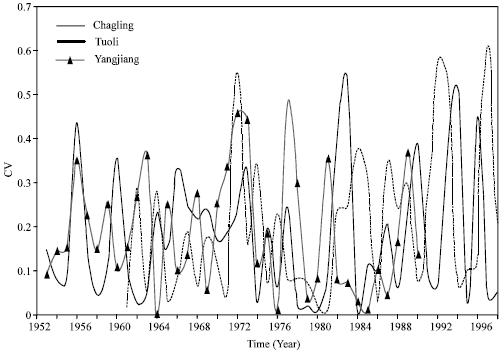
| Fig. 1: | Annual precipitation variations at three locations |
 | |
| Fig. 2: | Time cycles of annual precipitation at three locations |
At Changling the probability of the anomalous precipitation is about 50%, with the probability of the anomalously low precipitation slightly higher than that of anomalous high precipitation.
Multiple time cycles exist in the annual precipitations at these three locations (Fig. 2). For Yangjiang and Tuoli the time cycles are about 3 and 7 years and for Changling they are about 3, 4 and 7 years.
There is no significant statistical difference among the CF of annual precipitation at these locations (Fig. 3). For both Changling and Tuoli the average CF after 1980 is higher than that before 1980 (p<0.05). For Yangjiang it is slightly lower than that before 1980 (p>0.05). From this we can infer that precipitation fluctuation increased at Changling and Tuoli, but it decreased in Yangjiang at least during 1980-1990.
The evenness of precipitation in the growing season: There is significantly difference for the evenness of precipitation in the growing season, between Tuoli and Changling (p<0.01) and Yangjiang and Changling (p<0.01) (Fig. 4). Tuoli and Yangjiang have higher evenness of precipitation in the growing season than Changling. There was lower evenness of precipitation during the growing seasons at Changling in 1963, 1986, 1994 and 1997. It also happened at Tuoli in 1977, 1990 and 1997. At Yangjiang it happened in 1954, 1968 and 1988. From Fig. 5 it is obvious that after 1975 the cycle time of lower evenness of precipitation in the growing seasons decrease at Tuoli and Changling. By spectral analysis the time cycles of the evenness of precipitation in the growing season are shortened differently for three locations. For Yangjiang the time cycle decreased from 4 years before 1975 to 2.9 years after 1975.
 | |
| Fig. 3: | The coefficient of fluctuation (CF) of annual precipitation at three locations |
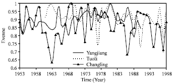 | |
| Fig. 4: | The evenness of precipitation in the growing season at three locations |
For Tuoli it decreased from 3.5 years to 2 years. But for Changling the time cycles were 11 and 3 years before 1975, after 1975 they changed into 11, 7 and 3 years.
Rapid seasonal changes in global precipitation have been observed to occur from May to June and from August to September[16,17].The even precipitation in the growing season is particularly important for the growth of crops, grassland and forests. Uneven precipitation generally results in flood and drought. Lower evenness of precipitation (flood and drought) during growing seasons would seriously affect the primary ecological processes of terrestrial ecosystems, such as decreased primary productivity. Rainfall variability can rapidly alter key carbon cycling processes and plant community composition[9]; carbon cycling processes such as soil CO2 flux, CO2 uptake by the dominant grasses and the aboveground net primary productivity were reduced.
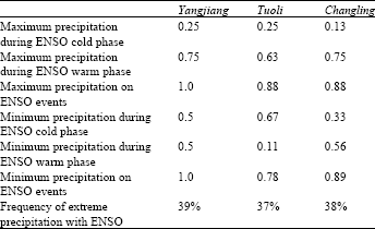
| Table 2: | The agreement between precipitation extremes and ENSO phases |
 | |
More rainfull and warm temperatures during germination and emergence would increase yield of corn in Missouri[18].
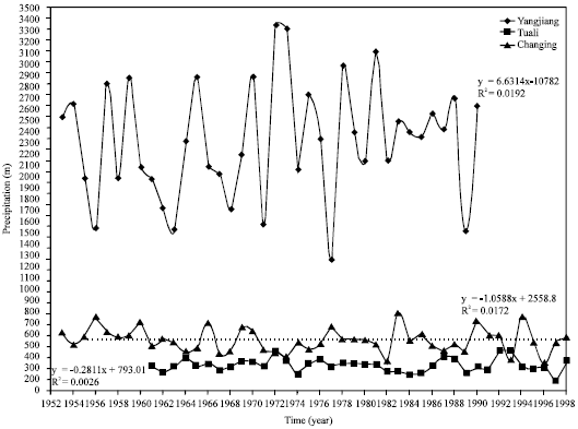
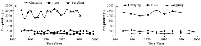
Precipitation change and its relationship with El Niño-Southern Oscillation (ENSO): The recent (1951-2001) ENSO activities (from http://www.cpc.ncep.noaa.gov/products/analysis_monitoring/ensostuff) can be described numerically by Fig. 5. The agreement between the peaks and troughs of annual precipitation and ENSO events is shown in Table 2. It is obvious that at these three locations the extreme precipitations have strong agreement with ENSO events, such as the agreements between maximum precipitation on ENSO events at Yangjiang, Tuoli and Changling were 1.0, 0.88 and 0.88, respectively.
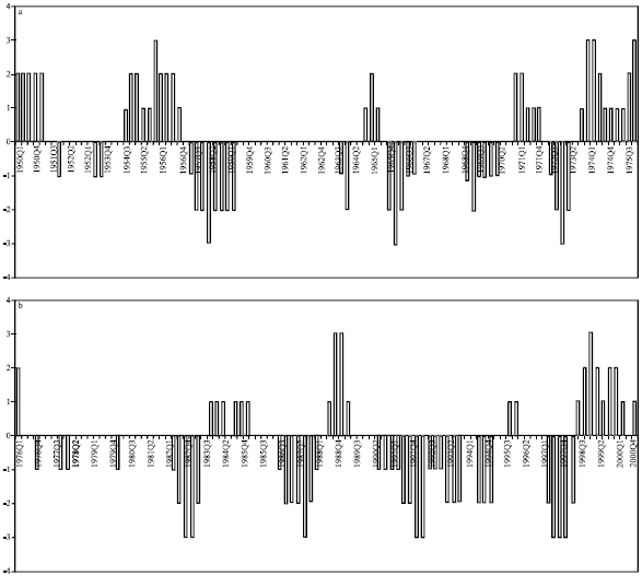 | |
| Fig. 5: | Recent ENSO events. (a) Before 1975 and (b) after 1975. Q1 means Jan., Feb. and Mar.; Q2 means Apr., May and Jun.; Q3 means Jul., Aug. and Sep.; Q4 means Oct., Nov. and Dec. Cold phase of El Niño is given value of 2, 3 and1 for cold, strong cold and weak cold, respectively. Warm phase of El Niño is given value of -2, -3 and -1 for warm, strong warm and weak warm, respectively. The normal climate condition is given value of 0. (adapted from http://www.cpc.ncep.noaa.gov/products/analysis_monitoring/ensostuff) |
The maximal precipitations have higher probability with ENSO warm phases and the agreements were 0.75, 0.63 and 0.75 for Yangjiang, Tuoli and Changling, respectively; the minimal precipitations have close relationship with ENSO cold phases and the agreements were 0.5, 0.67 and 0.33 for Yangjiang, Tuoli and Changling, respectively. Frequency of extreme precipitation with ENSO event is about 37-39% for the three locations. ENSO has a clear impact on the precipitation at these three locations (or from south to north and from east to west in China). Also, ENSO might greatly affect the evenness of precipitation in growing season. For Tuoli the year with minimal evenness at 1997, 1990 and 1977 coincided with ENSO warm phases, the same pattern occurred at Changling. However, at Yangjiang the years with minimal evenness usually coincided with ENSO phase transition.
ENSO is a disruption of the ocean-atmosphere system in the tropical Pacific and it has important consequences for weather around the globe. ENSO-related precipitation anomaly patterns have been already identified from analyses of land-based rain gauge stations[19,20]. Recent precipitation changes may be related with ENSO. Generally, most warm ENSO events typically result in below-normal rainfall and cold ENSO events result in above-normal rainfall. However, in our analysis of the three locations, the maximal precipitation had a higher probability of occurring during ENSO warm phases and the minimal precipitation had a close correlation with ENSO cold phases. Concurrent changes in the frequency and intensity of El Niño and La Niña events in the 1980s and 1990s were linked to Pacific decadal variations[21]. An analysis of the 40-year (1951-1990) Comprehensive Ocean-Atmosphere Data Set revealed that the onset and development characteristics of El Niño had experienced a significant change after 1976-77 El Niño[22]. ENSO can greatly affect the evenness of precipitation in the growing seasons; it can change the pattern of effective precipitation, which is the portion of precipitation that satisfies the growth requirement of plants. The rearrangement of precipitation patterns induced by the change from El Niño to La Niña conditions had significant effects on biomass production in arid and semiarid lands of Africa as revealed by NDVI anomaly patterns[23].
The precipitation variation in China is also impacted by monsoons[12]. However, the interaction of the monsoon with other large-scale climatological features, such as ENSO, is very complex and is therefore difficult to interpret[24]. The physical nature of a monsoon-ENSO teleconnection is often explained as an interaction between the Hadley circulation in the monsoon region with changes in moisture convergence driven by the trade winds and a perturbed Walker circulation during ENSO[25]. The net result of this interaction is a reduction in moisture transport into south Asia during El Niño events and an enhancement of convergence during La Nina events[26,27]. These theories may partly explain the precipitation variation at three locations in this study. However, an alternative explanation that precipitation trends in China over the past several decades might be related to the increased human-made black carbon aerosols and land use and water resource policies also had contribution[28]. But much more needs to be known about this hypothesis.
CONCLUSIONS
By analyzing of the recent precipitation variations at three locations (Yangjiang, Tuoli and Changling) in different climate regions of China, it is evident that precipitation variations at these three locations have both similar and different characteristics. Yangjiang has the highest annual precipitation fluctuation among the three locations. The probability of the anomalous precipitation at three locations is more than 50%. Multi-year cycles of the annual precipitation exist at these locations. The average coefficients of fluctuation at Changling and Tuoli after 1980 are higher than those before 1980, but for Yangling it is slightly lower than that before 1980. There is significant difference of the evenness of precipitation in the growing seasons between Tuoli and Changling, Yangjiang and Changling, respectively. Tuoli and Yangjiang have higher evenness of precipitation in the growing seasons than Changling.
The time cycles of evenness of precipitation in the growing seasons changed after 1975 at the three locations. Extreme precipitations have strong agreement with ENSO events at the three locations. The maximal precipitations have higher probability with ENSO warm phases and the minimal precipitations have close relation with ENSO cold phases. Frequency of extreme precipitations with ENSO events is about 37-39% for three locations. The uneven precipitation in the growing season is possible related with ENSO. The interaction between ENSO and monsoons may partly explain the precipitation variation at three locations in this study. However, further researches about the causes of precipitation variation and the effect on ecosystems are needed.
ACKNOWLEDGMENTS
Thanks to Dr. J. Ni for providing some information of weather station in China and Mr. Cameron Barrows for editorial assistance. This research was partially supported by the Center for Forestry and Ecology and Department of Plant and Soil Science in Alabama A and M University.
REFERENCES
- Saether, B.E., 1997. Environmental stochasticity and population dynamics of large herbivores: A search for mechanism. Trends Ecol. Evol., 12: 143-149.
CrossRef - Stenseth, N.C., A. Mysterud, G. Ottersen, J.W. Hurrell, K.S. Chan and M. Lima, 2002. Ecological effects of climate fluctuations. Science, 297: 1292-1296.
CrossRef - Fitter, A.H. and R.S.R. Fitter, 2002. Rapid changes in flowing time in British plants. Science, 296: 1690-1691.
PubMed - Vorosmarty, C.J., P. Green, J. Salisbury and R.B. Lammers, 2000. Global water resources: Vulnerability from climate change and population growth. Science, 289: 284-288.
CrossRefPubMedDirect Link - Knapp, A.K., P.A. Fay, J.M. Blair, S.L. Collins and M.D. Smith et al., 2002. Rainfall variability, carbon cycling and plant species diversity in a Mesic grassland. Science, 298: 2202-2205.
Direct Link - Krebs, C.J., 1998. Ecological Methodology. 2nd Edn., Addison-Welsey Educational Publishers Inc., USA.,.
CrossRef - Dai, A., I.Y. Fung and A.D. DelGenio, 1997. Surface observed global land precipitation variations during 1900-1988. J. Climate, 10: 2943-2962.
CrossRefDirect Link