
A. Mahmoudzadeh
Department of Biology, University of Urmia, Urmia, Iran
Pakistan Journal of Biological Sciences
Year: 2007 | Volume: 10 | Issue: 3 | Page No.: 388-392


ABSTRACT
To obtain, characteristics and behaviors of soil erosion phenomena, to control it’s harms and reduce it’s risks, realistic data from soil erosion rates are necessary. Mean while, measuring soil erosion rates particularly in large scale is a time consuming and expensive task. Moreover, spatial and temporal changes of soil erosion increase this problem. Therefore, to find out a certain way of creating capable methods which easily and quickly be able to estimate soil erosion rate, is quite logical. So, different models are widely used, but, may be the most important consideration with this regard is that, these models should be previously, tested and adopted to defined areas to stop probability of causing some huge and meaningful errors. Therefore, to achieve the above mentioned aim, different methods are used. Anyway, conditions which resulted to create a suitable model, should be considered in a defined area where, model is applied, unless, model application can leads to huge risks. This study is an attempt with this refer, that is, with comparing measured soil loss rates and predicted soil erosion rates from a defined catchment area, created a reasonable relationship between them and achieved the main aim of the study. That is, one of the small upland catchments of Emam kandi of Urmia with 75 ha area which is part of the Urmia lake catchment area and under layned by calcareous parent material, is selected as a study site. Selected catchment has natural pasture and has closured during the recent years. To calculate sediment yield the following processes were done: first, estimating the volume of trapped sediments, then, surveying the catchment area, for calculating sediment yield. Measured sediment yield is 6.19 t ha-1 year-1 which leads to soil loss rate of 13.76 t ha-1 year-1 by using Sediment Delivery Ratio (SDR). Also, inside the measurement of sediment yields and calculation of soil loss rates, two models of MUSLE and PSIAC were used respectively after exclosure and before exclosure to predict soil loss rates. Predicted soil loss rates by MUSLE and PSIAC respectively are 12.80 and 26.5 t ha-1 year-1. Finally, Comparisons and statistical analysis and scientific discussions were made.
PDF Abstract XML References Citation
How to cite this article
A. Mahmoudzadeh, 2007. Vegetation Cover Plays the Most Important Role in Soil Erosion Control. Pakistan Journal of Biological Sciences, 10: 388-392.
DOI: 10.3923/pjbs.2007.388.392
URL: https://scialert.net/abstract/?doi=pjbs.2007.388.392
DOI: 10.3923/pjbs.2007.388.392
URL: https://scialert.net/abstract/?doi=pjbs.2007.388.392
INTRODUCTION
Soil erosion is one of the pervasive forms of land degradation around the world, as well as Iran. For example, 12.5% of New South Wales of Australia is affected by sheet and rill erosion, 23.4% by gully erosion, 2.9% by mass movement and 10.3% by scalding (Graham et al., 1998). Soil erosion importance is often ignored by people, unless, they see a pervasive form of erosive evidence (Edward, 1988).
The challenge for soil conservation is to understand how erosion processes occur and how the fertile soil to be utilized for minimizing soil erosion impacts. The principle of conservation land use is to utilize the land according to its potential but conserve it according to its need (Mctainsh and Boughton, 1993). Although, this solution seems to be very simple, yet it is hard to achieve. Accelerated soil erosion by human beings in compare with natural processes of land denudation is responsible to increasing eroded material (Freebairn and Wockner, 1986).
Soil erosion often leads to continuing destruction of fertile top soil and so, fights with sustainable agriculture (Mahmoudzadeh, 1997).
Usually, poor and erodible soils in conjunction with low and highly variable rainfall, have made Australia particularly sensitive to soil erosion (Sanders, 1992). Ofcoure, mentioned characteristics which relate to arid regions partially, are also, seen in Iran as a part of arid region. Therefore, in Iran where, the same as Australia more than half of the country includes desertic and semidesertic areas, soil erosion is a high risk and different forms of it affects many parts of the country. An intensive rainfall event can easily detach 200 tones soil material, which can increase in areas with low vegetation cover. Unfortunately, in arid regions, usually, low vegetation cover accompanying the intensive rainfall events (Kardowani, 1988).
Therefore, necessarily, soil erosion harms might be decreased, so, to achieve this goal, soil erosion should wholly be introduced and it’ intensity be determined. To reach this important aim, a small pastured catchment with 44°, 59′, 10±-45°, 2′, 40± eastern longitude and 37°, 28′, 43±-37°, 51′, 28± northern latitude is selected as a study site. The study site is one of the upstream small catchments of Emam kandi catchment which in turn belongs to Urmia lake catchment area, in northwest of Iran (Jihad Sazandagi of Western Azarbaijan, 1997). Todays, using small dams as sediment traps is a known method of estimating sediment yield. Using this method leads to mean annual sediment yield. However, sediment yields can be converted to soil loss rates by using sediment delivery ratios of selected catchments. The resulted mean annual soil loss rates are useful for farmers and land holders to plan for most suitable strategy to control soil erosion.
Site description
Location of study site: All check dams which their sediments were measured for estimating soilloss rates, are located on a small upland catchment area. Figure 1 shows the location of study site on the map of western Azarbaiajan and Iran. That is, the study site belongs to hyrdrographic unit of A5.
Physiographical situation of study site: Evaluation of physiographical and topographical situation of study area is necessary and includes the principals of soil conservation study and is very important for watershed management purposes. Therefore, in any planning for conservation programs including mechanical and biological practices under a sustainable use of natural resources such an evaluations are needed.
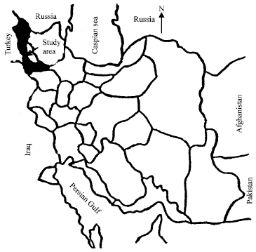 | |
| Fig. 1: | Location of study site on the map of western Azarbaiajan and Iran |
| Table 1: | Some of the physiographical characteristics of hydrological units of Emam kandi catchment area |
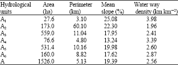 | |
Maximum and minimum altitudes in Emam kandi catchment area are respectively 2230 and 1280 m | |
The most important physiographic characteristics are: surface area, perimeter, main water ways length, slope steepness, catchment shape, altitude from sea level, concentration time, hydrographic web and etc. Generally, Urmia lake catchment area and particularly study area is mountainous. Eman kandi catchment area is 1526 hectars and is divided in to 6 hydrological units. Some of the physiographical characteristics of hydrological units are shown in Table 1. The study area is under native pasture and dominant species are: Bromus tectorum, Verbascum aucher, Cynodon dactylon, Medicago sativa, Juniperus excelsa and Salix alba (in the bottom of main water ways).
Climatological and hydrogical situation of study area: Climatological conditions particularly, rainfall and temperature are very important and effective on soil erosion trend. In additions, climatologic and topographic conditions highly affect the hydrologic condition, which has high importance in detachment and sediment transportation. Study site has semi-arid climate, with mean annual rainfall of 350 mm minimum annual temperature of -22°C and Max annual temperature of 38°C.
MATERIALS AND METHODS
Sediment yields: Study site as a small part of Urmia lake catchment is located in western Azarbaiejan of Iran, with a longitude of 44°, 59′, 10±-45°,2′,40± east and a latitude of 37°, 48´,43±-37°, 51´, 28± north.
The method which is used in this study to determine soil loss rate on a single pastured catchment with 75 hectars area and a sediment trap dam in it’ outlet and some small sediment trap dams on main water ways of the catchment, based on surveying the catchment area and the trapped sediments behind the dams. That is, the small dams trap water and also sediment loads. Meanwhile, the trapped sediments belong to whole catchment area, in other hand, they are part of detached materials from the catchment surface area. So, to determine soilloss rate, sediment yield is needed. To calculate, sediment yield, catchment area, mass of trapped sediment might be estimated. Therefore, volume of trapped sediment is calculated by multiplying the surface area of reservoir by mean sediment depth. As, the sedimentation period also is known, then sediment yield can be estimated by dividing the whole sediment mass by production of sedimentation period (year) and catchment area (ha). Figure 2 shows the base of this method.
One of the main criteria to use this method is the selection of suitable study sites. That is, the selected site should be located on upland areas of main catchment and also, this small catchment, might be has a small dam in it’ outlet without spillway runoff. Moreover, catchment area had homogeneous land use, that is, the same catchment land use had been maintained throughout the life of the dam. Dams only stored runoff from the upstream catchment (i.e., there were no inter-basin water transfers into or out of the catchment).
The method of Neil and Galloway (1989) was used to survey the dams. Sediment cores were collected at a number of points in each dam. A gouge auger was used to obtain sediment cores, which always penetrated the dam sediments into the underlying in sito soil or saprolite. Dam sediments were readily discriminated from the underlying materials on the basis of a lower bulk density, darker soil colour and fine texture.
By using Walkley-Black method, the organic matter percent was determined and hydrometer method was used to determine the soil texture for all soil and sediment samples. Figure 3 demonstrates the schematic position of sediment cores.
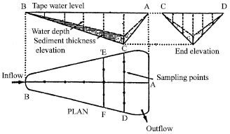 | |
| Fig. 2: | Farm dam survey method (after Neil and Galloway, 1989) |
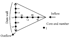 | |
| Fig. 3: | Shows the schematic position of sediment cores |
To use sediment yields for estimating the soil loss rates, Sediment Delivery Ratio (SDR) and Sediment Trap Efficiency (STE) are needed. For selected small dam with small catchment area, as the dam had no spillway runoff during it’ sedimentation period, the STE considered to be 100% and SDR estimated from the equation of Walling (1983).
Predicted soil loss rates: Inside the measured sediment yields and calculated soil loss rates two models also were used: Modified Universal SoilLoss Equation (MUSLE) and the Pacific Southwest Inter Agency Committee (PSIAC), respectively after exclosure and before exclosure to predict soil loss rates.
RESULTS AND DISCUSSION
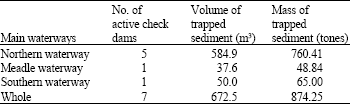
Measured soil loss: The volume of deposited sediments behind the constructed check dams in catchment outlet and other segments of main waterways according to the methodology of study are shown in Table 2.
Meanwhile, 653.93 m3 sediment has been trapped by an unsealed road which is constructed in time of dam construction. That is, by considering bulk density of trapped sediment with coarse material and light texture (1.3) sediment mass is 850.11 tones, so, total trapped sediment mass is 1724.4 tones. As a result mean annual sediment yield is:
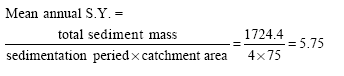 |
The latest figure (5.75) by considering sediment delivery ratio (45%) which obtained by using walling’ curve, gives soil erosion rate from catchment area (12.77 t ha-1 year-1).
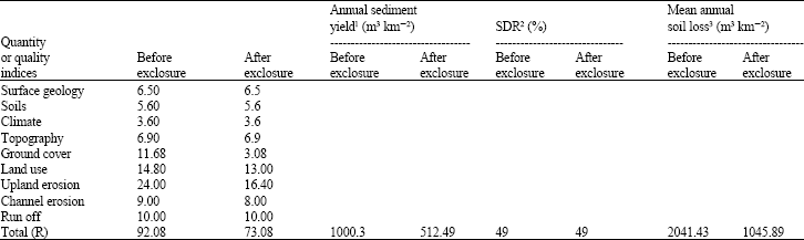
Predicted soil loss: To predict soil loss rates of study area semiquantitative method of Pacific Southern InterAgency Comytee (PSIAC) inside with imperical method of Modified Universal Soil Loss Equation (MUSLE) are used as fallows: Table 3 shows the evaluated indices for PSIAC (De Vente et al., 2005).
| Table 2: | Active checkdams and trapped sediments |
 | |
| Table 3: | Trend of using PSIAC indices before and after exclosure in hydrologic unit of A5 |
 | |
1For calculating the sediment yield the fallowing equation is used Q5= 38.77e(0.0353R), 2To estimate the sediment delivery ratio walling’s curve is used, 3By using bulk density (1.3) the volume of sediment converted to mass | |
| Table 4: | Indices needed to use MUSLE (after exclosure) |
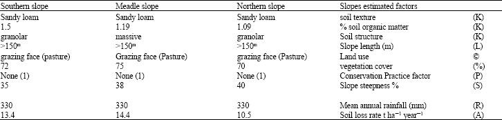 | |
| A = RKSLPC, A = 12.8 | |
| Table 5: | Comparing measured and predicted soil loss rates |
To use PSIAC, nine factors namely (surface geology, topography, landuse, ground cover, climate, soil, upland erosion, channel erosion and run off) are evaluated and used for study area, which resulted to soil loss rate of 26.54 t ha-1 year-1. The resulted soilloss rate refers to before exclosure.
Moreover, after exclosure using MUSLE and PSIAC models resulted to respectively soil loss rates of 12.8 and 13.60 t ha-1 year-1. 12.8 t ha-1 year-1 is the mean for three selected slopes from study area. Table 3 represents the trend of using PSIAC indices before and after exclosure in hydrologic unit of A5. Table 4 shows the quantity of indices used to predict soil loss by MUSLE after exclosure.
As it comes from Table 5, difference between the results of using PSIAC and MUSLE and also, the measured result with predicted result by PSIAC is very high and quite significant. It should be mentioned that measuring sediment yield and predicting soil loss rate by MUSLE has been done in 2002, but predicting soil loss rate by PSIAC were done in 1996.
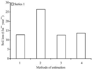 | |
| Fig. 4: | Demonstration of pervasive role of vegetation cover in controlling soil loss. 1) Measured soil loss after explosure, 12.77, 2) Predicted soil loss by PSIAC before explosure, 26.54, 3) Predicted soil loss by MUSLE after explosure, 12.80, 4) Predicted soil loss by PSIAC after explosure, 13.60 |
To control high soil erosion rete, the area exclosured from 1996 till now. During exclosure, vegetation cover improved highly and so, soil erosion rate decreased significantly, which is clearly seen in Table 5. Most probably, the most important factor in decreasing soil erosion rate is improved natural pasture in study area. Except, the difference between soil loss rates before exclosure and after exclosure, other differences are not significant, which represented by Fig. 4. So, Wilson’s (1973: 348) quote is an appropriate conclusion with this regard: The most important non-climatic variable influencing Sediment yield is land use. The human influence on erosion processes is so pervasive that attempts to study sediment yield variations are likely to be unsuccessful unless land factors are considered.
ACKNOWLEDGMENTS
My deep thanks goes to land owners and farmers of Emam kandi and all people who are working in State Department of watershed management.
REFERENCES
- De Vente, J., J. Poesen and G. Verstraeten, 2005. The application of semquantitative methods and reservoir sedimentation rates for the prediction of basin sediment yield in Spain. J. Hydrol., 305: 63-86.
CrossRefDirect Link